


mardi bain.de.boue

craninxluc
User
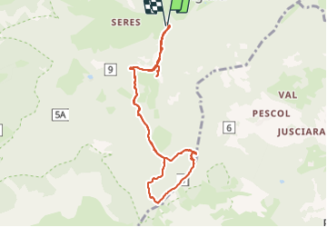

Length
8.8 km

Max alt
1747 m

Uphill gradient
326 m
Km-Effort
13.1 km

Min alt
1456 m

Downhill gradient
326 m
Boucle
Yes
Creation date :
2023-10-24 13:03:23.137
Updated on :
2023-10-24 16:30:24.789
3h26
Difficulty : Difficult

FREE GPS app for hiking
 SityTrail
IGN / Geographical institutes
SityTrail Plus
The world is yours!
About
Trail Walking of 8.8 km to be discovered at Trentino-Alto Adige/Südtirol, South Tyrol, San Martin de Tor - San Martino in Badia - St. Martin in Thurn. This trail is proposed by craninxluc.
Positioning
Country:
Italy
Region :
Trentino-Alto Adige/Südtirol
Department/Province :
South Tyrol
Municipality :
San Martin de Tor - San Martino in Badia - St. Martin in Thurn
Location:
Unknown
Start:(Dec)
Start:(UTM)
718661 ; 5168698 (32T) N.
Comments